|
|
|
Our Tech Examples Applications FAQ Index Sales
|

|
Other WAY-2C Applications |
Multi-Spectral and/or Multi-Sensor Fusion
|
The normal human vision system has the remarkable ability to
classify objects based on the distribution in space of
the red, green, and blue color components of light emanating from the objects.
This ability can be exploited to classify based on the distribution of
any three variables by creating a "false color" image in which
each variable is assigned to a different color component.
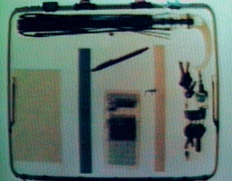
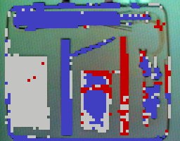
For example, this false color image results from the combination of images from two different sensors in a simulated baggage inspection system. Suspicious organic materials appear reddish brown, automatically detectable by
|
|
Relevance Spectroscopy -Hyperspectral Image Analysis
|
We have recently been awarded US Patent 8,918,347 for an automated method of rapidly
determining the optimum combination
of available sensor variables to differentiate any particular set of target classes.
This method, which we refer to as relevance spectroscopy has been demonstrated
by experimental studies on a variety of multispectral and hyperspectral aircraft
and satellite images. The resulting combination is suitable for analysis by traditional
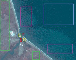
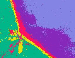
and/or our maximum likelihood methods. The upper image was created from a set of three monochrome images automatically chosen from a set of over two hundred images, each representing a different spectral band. In this case the band combination was chosen to optimize differentiation of certain water and shoreline classes while suppressing differentiation of land vegetation classes. Training regions for each class are outlined by the red, yellow, purple, and blue rectangles with each color representing a different class. Note how land vegetation regions are combined into a single class whose training regions are outlined by the green rectangles.
The resulting |
  |
Surveillance
Best Focus, Time-Series Monitoring and Other Pattern Recognition Applications
The technology now contained in
Now that
Accounting and transaction records often show characteristic, organization specific,
statistical patterns.
Physiological, motion monitoring etc. signals can often provide information
on a subject's current activity.
Non-image data sets which
If you have data analysis applications that might benefit from robust automated statistical pattern recognition methods, contact Robert McConnell for a free confidential evaluation.
Thermal Transient Analysis
By assigning thermal images from a single scene obtained at different times to different image planes,Live Clams and Mud Clams

|
One of these clams is alive, the other is a "mudder", dead and partially filled with mud.
Both have about the same density.
Can you tell them apart? Not from this image! However, we have invented a proprietary
method for differentiating them. If you process millions of clams or similar shellfish
per day, and are interested in automatically detecting and rejecting the dead ones,
please contact us.
|